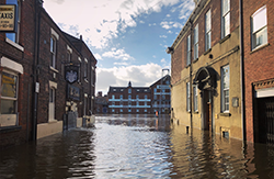
Flood affected cycle paths
The following cycle paths in York are susceptible to flooding, depending on river levels.
This is provided as general guidance as to the effects of flooding on our network of cycle paths.
Always check conditions before travelling and never cycle through floodwater.
River Ouse flooding
If the River Ouse overflows the following may be inaccessible:
- New Walk - Hospital Fields Road to Blue Bridge and Blue Bridge to Tower Gardens, including Tower Gardens
- Browney Dyke - Blue Bridge to Tower Street
- South Esplanade - Tower Gardens to Kings Staith, including Kings Staith
- Terry Avenue - Millennium Bridge to Skeldergate, including Skeldergate
- Millennium Bridge to the former Terrys site alongside the river and at foot of ramp up to the Terrys site
- Butcher Terrace approach to the Millennium Bridge
- Esplanade - Lendal Bridge to Scarborough Bridge, York Rowing Club side of the river
- Post Office Lane at Scarborough Bridge end
- Cinder Lane - Jubilee Terrace to Scarborough Bridge - usually only floods at the Scarborough Bridge end but makes the whole path unusable as no diversion available
- Esplanade - Lendal Tower to Marygate and beyond to Scarborough Bridge
- Riverside path - Scarborough Bridge to Clifton Bridge and Water End, on St Peters School side of river
- Clifton Ings - Clifton Bridge and Water End to A1237 Outer Ring Road
- Rawcliffe Ings - A1237 Outer Ring Road to Stripe Lane Skelton
River Foss flooding
If the River Foss overflows cycling access on the following routes could be affected:
- Foss Islands Road
- James Street
- Hungate Bridge, Navigation Road
- Foss Bank
- Huntington Road
- Piccadilly
- The Old Village, Huntington, to Joseph Rowntree School
Foss Islands cycle path flooding
During very heavy or sustained rain the Foss Islands Cycle Path may be flooded full width in some places due to the length of time it takes the water to drain away.
The locations which can be affected are:
- under Layerthorpe Bridge
- immediately east of Ambleside Avenue access
- section between Layerthorpe Bridge and Hallfield Road
Tang Hall Beck flooding
If Tang Hall Beck overflows the following sections of the Foss Islands Path could be affected:
- St Nicholas’ Field to James Street, including the paths around the Travellers Site
Monitor flood warnings and river levels in York.
Flood information